So we went back to Brussels, and found our beautiful apartment in town.
--Arthur Lubinski, 1988
I found my wife, of course a little upset, but still quieter than me. She knew already that the war burst but she did not see incendiary bombs dropped from the sky and did not feel the mighty blast of explosive bombs. “You will never return to our home at avenue de Mai, my dear," I said to her.
--Arthur Lubinski, 1940s
Really, this is just a continuation of my making connections down through time article, about how there are generous people are willing to help complete strangers with research. And the cool tech that helped me this time: Google Streetview, and a historical arial photography website for the city of Brussels. They both gave me information about locations and neighborhoods.
Anyway, I wrote to a historical society in Brussels that is devoted to the history of Woluwe-Saint-Lambert, the township in Brussels where my grandparents lived. More specifically I wanted to know if this apartment building in Brussels had been built before the war (hence, it is the actual building they lived in?), or after the war (so not the building they lived in)?
In other words, if I describe THIS building in my grandparents' stories, would it be accurate?
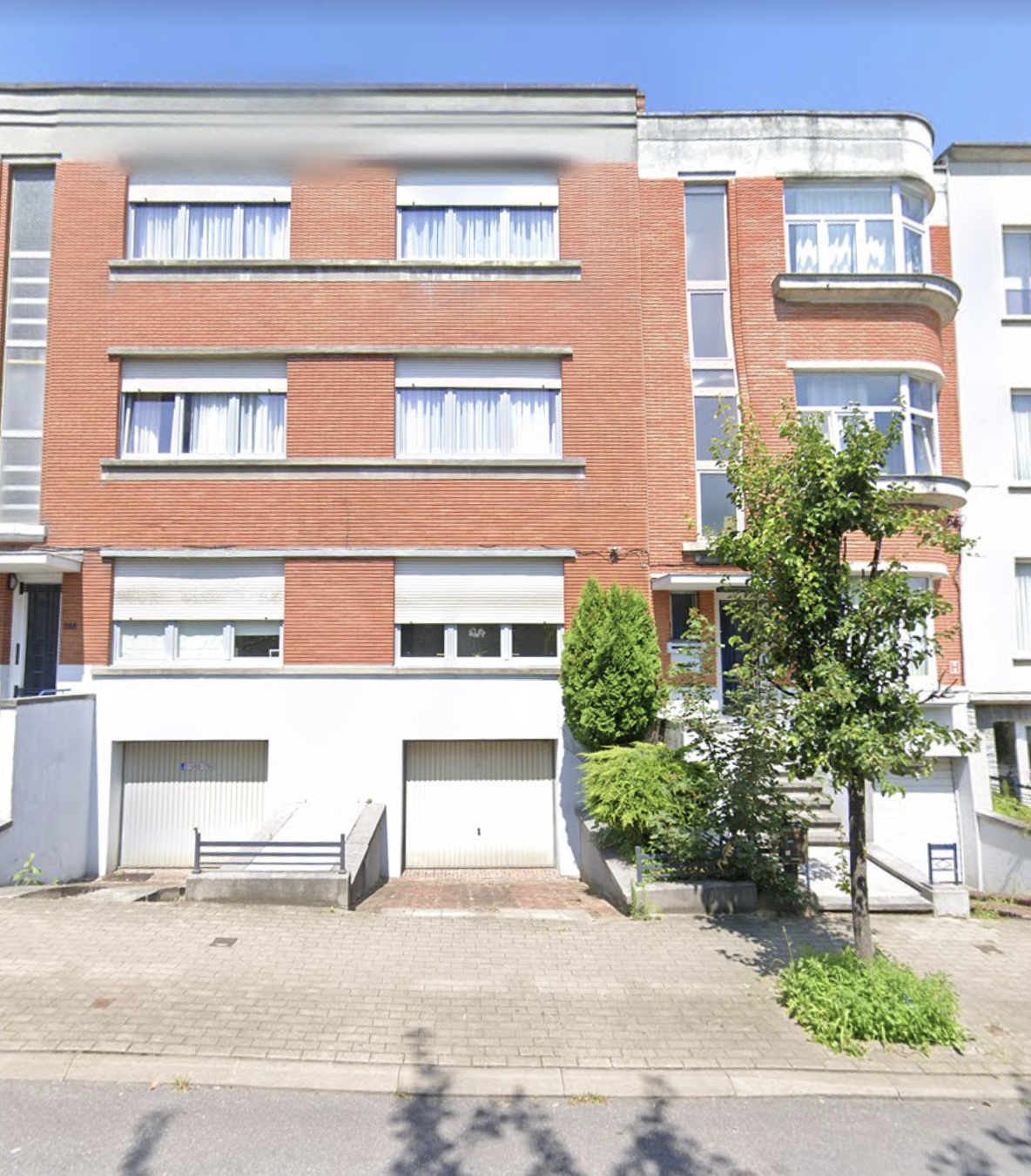 |
| 286 Avenue de Mai Note the curved sunroom on the right. That's how I placed which building it was in the photos. |
Here's the answer I got:
Dear Ms. Weeks,
This building was built during the interbellum, probably in 1935-1936 (permit from June 1934). The houses nr. 286, 288 and 290 constitute an ensemble built by three different owners. Number 286 was built by the architect who designed the ensemble, Paul Aernaut. There are indeed three apartments in this house.
I invite you to check on Bruciel (it would be “Brusky” in English), you will see an aerial photography from 1930-1935 of this very building being built!
My department is responsible for the ‘duty to remember’ in Woluwe-Saint-Lambert. We make a lot of research about occupation and resistance during the war, so I would love to hear more about your family’s history. Also don’t hesitate to get in touch with me if you have any further question about WWII in Brussels.
Regards,
S---- F-----
Ok, this is excellent news! And so YES, that is indeed the apartment my grandparents lived in, when my aunt was born. That makes me very happy.
Here it is in on the map. Note the pink heart pin - that's 286 Ave de Mai.
 |
| Ave Herbert Hoover and Ave de Mai make a wedge-shaped neighborhood. |
Note the wedge-shaped neighborhood. They are close to the narrow end of the wedge, and in my stories, I'd written that they grew vegetables in the courtyard behind the building, but ... that doesn't look like there's much space for a garden there, particularly if you consider the building on Herbert Hoover that is directly north of my grandparents' apartment. So, using Google Streetview, I looked at that building. Is it modern or old? Is my understanding of the size of the space correct?
In the picture below, the building north of 286 Avenue de Mai is the one on the right with the gray wall, with the back of my grandparent's building peaking through the gap between it and the next building:
 |
| Balcony? |
Wait? Grandpa and Grandma had a balcony? Did people grew food in containers on those balconies? But ... yeah. Not much space and maybe not much sun exposure - that space behind the building is on the north side of the building. Given the food shortages during the war, I'm sure that if there WAS any usable green space, that it probably would have been used to grow food.
So then I decided to look up the historical arial photography site the historian sent me, and ... whoa. Pay dirt!! Take a look:
 |
| 1935 or 1936 - during construction. Lots of open space. But that building behind it wasn't there. |
 |
| 1944: The building behind it appears to be there. I suspect that new construction probably didn't happen DURING the war, so my guess is that it was built prior to 1939. But, note that there appears to be open space to both the left and right. |
 |
| 1953. Much clearer picture, but little change from 1944. That is definitely open space to left and right. |
 |
| 1944 closeup of the open space to left of building. |
 |
| 1944 closeup of the open space to right of building. |
Note: Here's the Belgian arial photography site if you want to play with it.
The Belgian historian had a colleague search the population registry, and found two dates: They moved into this apartment on August 27, 1937, and more interestingly, moved out on February 20, 1942, to Rue Stroobant, 42 in Ixelles. I don't have any reason to doubt the move-in date, but I know the later date was false; I suspect it was some sort of deliberate falsehood designed to cover their escape to France in the fall of 1941 (and I have letters that establish their location in France in late 1941).
I can't be sure what it looked like on the inside, but there are a few pictures in my grandparents' photo album that were probably taken in that apartment (click to enlarge):
 |
| Grandma was about 8 months pregnant with my Aunt Lilly. The war had not yet started in Western Europe. Note the record player - Grandma loved music. |
 |
| Aunt Lilly and the record player. This was taken only a few months before they escaped to France. |
 |
| Grandma Roma and a 5-month-old Aunt Lilly |
 |
| Lilly had a bassinet (as well as a crib as shown below) |
 |
| Grandpa and Aunt Lilly. They were probably already planning for their escape. |
 |
| Lilly's crib. Note the briefcase in the background. I wrote about Grandpa's briefcase in the book. |
No comments:
Post a Comment
Neither spam nor mean comments are allowed. I'm the sole judge of what constitutes either one, and any comment that I consider mean or spammy will be deleted without warning or response.